Section 7 - Environment and Navigation Menu
90-8M0070299 eng MAY 2012 Page 97
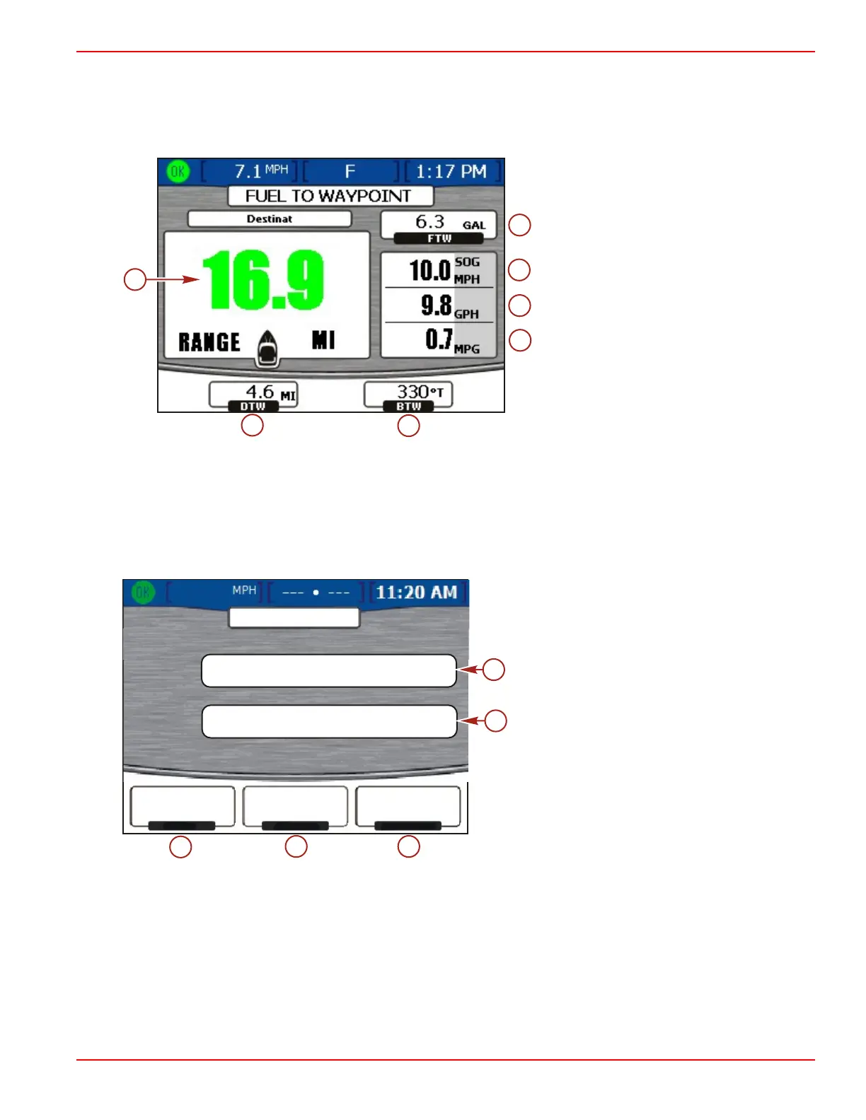
Viewing Fuel to Waypoint Data
The "FUEL TO WAYPOINT" screen displays dynamic travel information with a GPS unit connected. The range to waypoint will
show the estimated distance the engines will run at the current speed with the fuel available. If the distance to waypoint is less
than the range to waypoint, the range distance will be green. If the distance to waypoint is more than the range to waypoint, the
range distance will be red. For the most accurate data, maintain bearing to the waypoint destination.
a - Range to waypoint
b - Distance to waypoint
c - Bearing to waypoint
d - Fuel to waypoint
e - Speed over ground
f - Total fuel flow rate
g - Fuel economy
• If you have set a waypoint on your GPS unit, the distance to waypoint (DTW) option shows the remaining distance.
• The speed over ground (SOG) option displays the boat's speed as calculated by the GPS unit.
• The fuel to waypoint (FTW) will display the estimated amount of fuel needed to reach the waypoint.
• Displays the total fuel flow rate and fuel economy.
Viewing Navigation Data
The "NAVIGATION" screen displays information from a connected GPS unit and is available on gasoline engines only.
a - Latitude location coordinate
b - Longitude location coordinate
c - Distance to waypoint (DIST WPT)
d - Speed over ground (SOG)
e - GPS heading
• Latitude and longitude are displayed based on available GPS data.
• If you have set a waypoint, the "DIST WPT" box shows the remaining distance.
• The "SOG" box displays the boat's speed as calculated by the GPS unit. Due to wind and current, this value may differ
from the speed in the water.
• The heading is calculated by the GPS unit. Due to wind and current, this heading may differ from your course over ground.
LAT
LON
DIST WPT
SOG
HEADING
1.5
10.0 23
MI
MPH
T
O
NAVIGATION
20 20.328 S
157 44.502 W
o
o
a
b