93
93
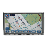
Types of 3D objects
The following 3D object types are supported.
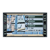
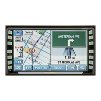
Items displayed during route navigation
The route is displayed using the following methods.
Type Explanation
3D Undulations On a 2D map, the changes in topography or undulations in the ground are
displayed; and when using 3D this data is used to create a route map image
during navigation. On a 3D map, hills and mountains are displayed in the
background, whilst on a 2D map they are expressed using changes in colour
and shading.
Elevated Roads Complicated intersections and three dimensional road objects (such as
overpasses or overhead bridges) are displayed in 3D.
3D Landmark 3D landmarks are realistic 3D representations of the most important
landmarks in major cities, and 3D city maps contain block representations of
buildings in the downtown areas of major cities. 3D landmarks are unique
drawings representing the true look of buildings, while in 3D city maps,
buildings are generated by the software from a database containing their
shapes and sizes.
Besides making the map view more attractive, these 3D features also help
the user navigate in the complicated street network of large cities by
providing easily recognisable reference points to the eye.
Symbol Name Explanation
Current GPS
position and
departure point
Current location of the user displayed on the map
● When you select a vehicle in route search, and if there is a road
nearby, the position of the icon is corrected based on the nearest
road.
When the GPS position is available, the route usually starts from the
current position. If there is no GPS position available, the last
confirmed available GPS position is used as the departure point.
Waypoint (midway
point)
The midway point target point before arrival at the target destination.
Destination (final
point)
The final destination on the route.
Route colour Displays using colours that are easy to understand and that stand out
in daytime or nighttime colour mode.
Roads excluded
from navigation
Select whether or not to exclude a road from navigation. (See page
148)However, if it is impossible to avoid a road that has been excluded,
that road is displayed in a different colour from the original route.
Roads affected by
traffic conditions
Any section of the road may be affected depending on the received
traffic conditions. Roads affected by traffic conditions are displayed in a
different colour, and a small icon representing the type of traffic
condition is displayed at the side of the route.