21. MISSING LINE MEASUREMENT
142
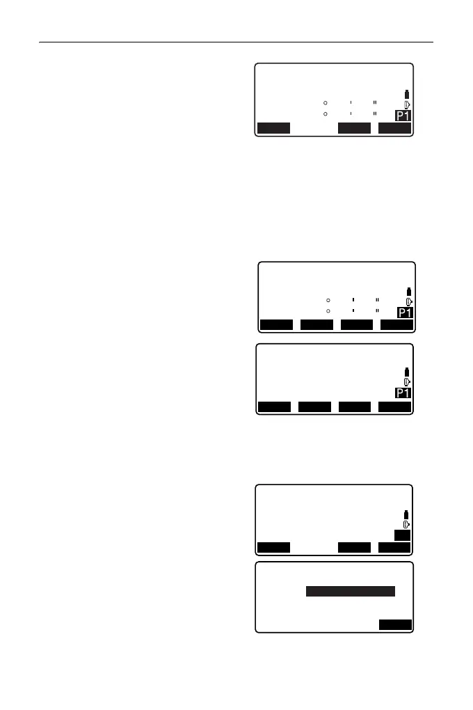
2. Sight the 1st target and press
[MEAS].
• If the distance measurement
data remains, the last measured
distance data is set as the
starting point, and the screen in
step 3 is displayed.
• The tilt screen is displayed if the
instrument is out of level.
Level the instrument.
"7.2 Levelling"
3. Sight the second target and press
[MLM] to begin observation.
• [REC]: records 1st target
measurement results.
The following values are
displayed:
SD: Slope distance of the starting
position and 2nd target.
HD: Horizontal distance of the
starting position and 2nd
position.
VD: Height difference of the
starting position and 2nd
target.
• Target height of the starting
position and 2nd target can be
input.
Press [Tgt.h] on the second
page.
Input the target heights and
press [OK].
•Press [COORD] to input
coordinates.
"PROCEDURE
Calculating from input
coordinates"
MLM
Set PT1
SD
ZA
HA-R
80
140
42
42
15
15
MOVE MLMMEAS
MLM
Set PT2
0.123m
SD
ZA
HA-R
80
140
42
42
15
15
REC
MOVE
MEAS MLM
MLM
SD
HD
VD
20.757m
27.345m
1.012m
RECMOVE MEAS MLM
MLM
Tgt.h
S/%
COORD
SD
HD
VD
20.757m
27.345m
1.012m
P2
Target height
PT2
OK
1.500m
PT1
1.500m