91
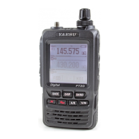
GPS Screen Information and Operation
Activating the GPS function displays the following information on the LCD.
①
②
③ ⑥
⑤
④
➀ Displays the satellite azimuth and elevation angles. Displays in North-up mode.
➁ Displays the date and time.
➂ Displays the current speed.
➃ Displays the satellite number and reception level.
➄ Displays the latitude on the upper side of the screen whereas displays the longitude
on the lower side of the screen.
The current position appears using north (N) or south (S) latitude.
Display format: X DD° MM. MMM
X: X=N: North latitude, X=S: South latitude, DD: Degree, MM:MMM Minute
Example: N 35° 38.250 (35 degrees, 38 minutes, 15 seconds north latitude)
The current position appears using east (E) or west (S) longitude.
Display format: X DDD° MM. DMMM
X: X=E: East longitude, X=W: West longitude, DDD: Degree, MM:MMM Minute
Example: E 139° 42.500 (139 degrees, 42 minutes, 30 seconds east latitude)
➅ Displays the altitude of the current position “ALTI xxxxm”.
Example: ALTI 20m
Displaying the GPS Information
Follow the steps below to display the GPS information.
1 Press the key.
Displays the navigation screen.
2 Touch the compass on the screen.
The GPS data is displayed.