Software v3.0.11065
© Satmap Systems Ltd 2017
18
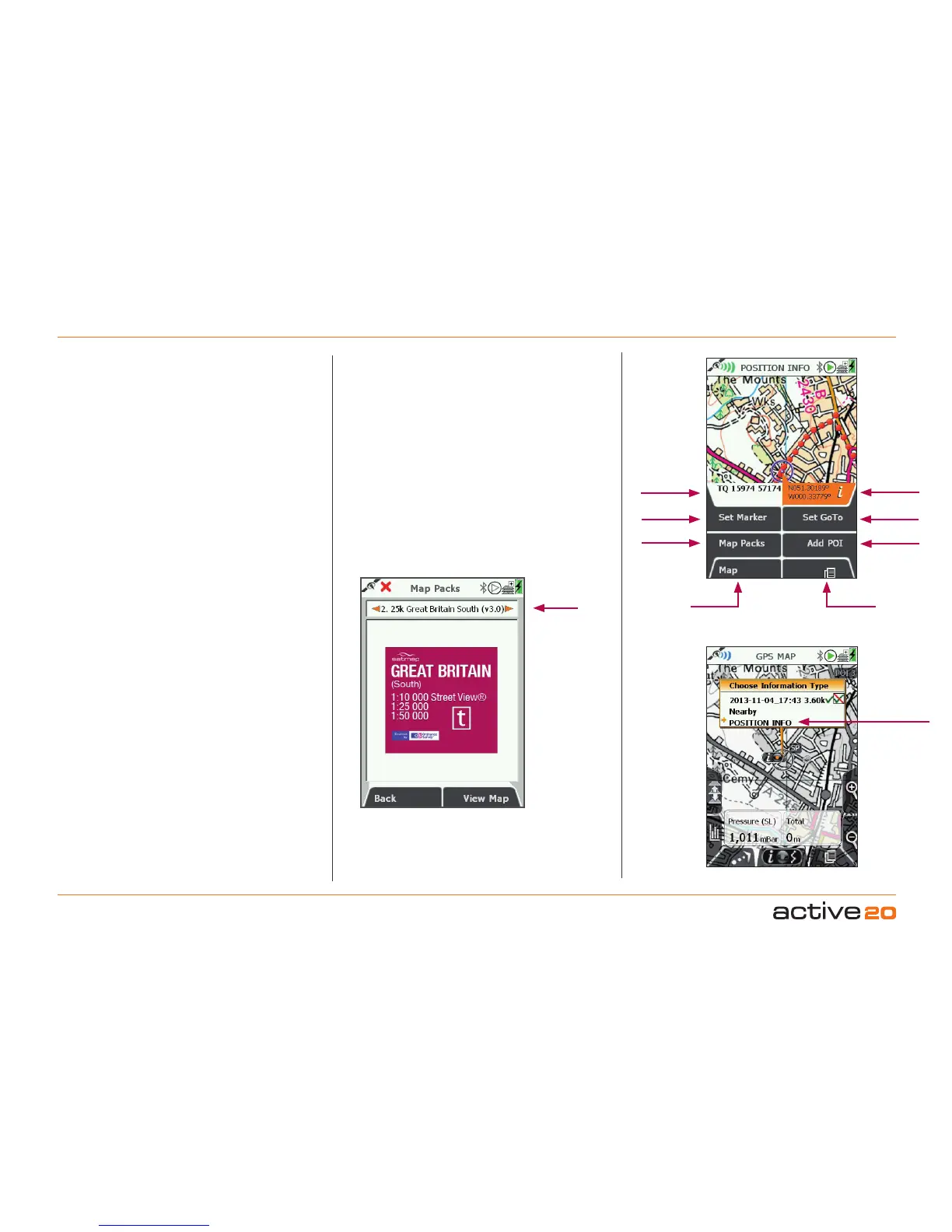
4.3 Screen3:POSITIONINFO
GPSMap
Primary
Screens
AddPOI
SetGoTo
Lat/Long
SetMarker
LocalGrid
MapPacks
ToaccessPOSITIONINFOScreen:
(GPS MAP / PLANNING → POSITION INFO, via
Primary Screen page forward)
The POSITIONINFO screen is accessed from either
the GPSMAP or PLANNING screens screen either
by a centre press of the rocker pad, or by pressing
the PrimaryScreen button once.
The purpose of the POSITION INFO screen is to
display useful information about that particualr
location, be it your own location (GPS MAP) or
somewhere else on the map (PLANNING).
Buttons:
SetMarker-This function allows you to measure
the distance and bearing between any two points on
the map, the first point being the centre of the circle
in the middle of the screen, and the second point
being any that you cursor to with the rocker pad,
connected by a red line. Cleared by using the Clear
Markerbutton.
MapPacks-Allows you to see the maps that are
present on your SD MapCard. A separate BookCover
will be displayed for each of the MapPacks present
on the SD card.
Maps - Flicks you back into your previous map
screen
(GPSMAPorPLANNING).
PrimaryScreens-Pages forward to the TRIP LOG
screen.
AddPOI-Will place a POI menu at the centre of the
circle. A defult name will be given (e.g. POI 1) that
can be over written, and a POI Icon can be selected.
SetGoTo-This function places a GoTo waypoint
at the centre of the circle. A solid blue line will then
connect your location to the GoTopoint at all times,
until the ClearGoTobutton is pressed.
This is a particularly useful and quick way of setting a
simple, single-leg route. Especially when zoomed in
to view map detail, and when in Track Up mode, the
GoTo line still shows the required direction.
InfoBoxes:LocalGrid&Lat/Long-
This features allows the location of the circle centre
to be simultaneously displayed in two grid formats.
The format of Local Grid is determined in the
SETTINGS/GPSSettings screen.
The format of the right hand box has be pre-set as
Lat/Long (decimals). This feature is very useful if you
may need to quickly convert one position format into
another: simply use the rocker pad to cursor to the
desired location, and then read off the other format
version of the grid reference.
Alternate
accessif
cursoris
onaRoute
orPOI
Map title
Exampe"BookCover"