Software v3.0.11065
© Satmap Systems Ltd 2017
27
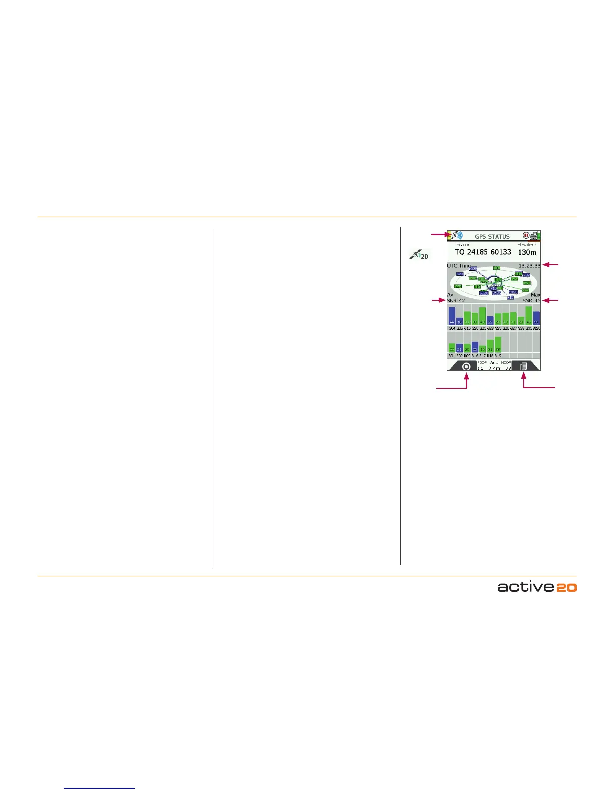
4.9 Screen9:GPSSTATUS
AccessGPSSTATUSscreen
(GPS MAP/PLANNING → POSITION INFO → TRIP
LOG → MAIN MENU → COMPASS → SHARED
DATA → GPS STATUS)
This is the screen that is first displayed when
switching on the unit (unless there is already a map
card inserted in which case the unit will briefly show
theMapPacks screen.
The elliptical diagram represents the sky above
you where North is the top of the ellipse. Satellites
(Satellite Vehicles = SVs) visible to the unit are
allocated numbers and also shown on the bar chart.
Blue bars indicate the unit can "see" an SV. The
bars change to Green when the data from an SV is
used in the position Lock. There are also indications
of "Signal to Noise Ratio" (Av SNR and Max SNR).
Before acquiring a lock, details of your last known
position, with time, date, and grid reference are
shown at the top of the screen. (Grid reference
format options are given inGPSSettings,‘Position
Display Format’).
Once you have a lock, your current coordinates and
elevation are shown. As a guide, a minimumoffour
satellites are needed to acquire a lock.
To access the GPSSTATUS screen from the GPS
MAP screen, keep pressing the Primary Screens
button (front right button) until you reach the GPS
STATUS screen.
The signal indicator (either red cross or green/blue
signal icon) indicates the strength of signal received
by the unit. The GPS indicator caption at the bottom
of the screen either says ‘Acquiring GPS’ or gives
accuracy to within a certain distance.
If the unit is receiving a poor signal e.g. under
wet tree canopy, it may only be able to give two
dimensional data, i.e. no elevation data. Under
these circumstances the elevation caption at the
top right of the screen will show ‘2D’ instead of an
elevation figure. The signal received icon at the top
left will also show a single green crescent plus ‘2D’.
AccuracyValues(Acc)
For those interested in other satellite data, an
Accuracy figure is provided: less than 2m is very
good, and less than 6m is accepatable, depending
on the prevailing conditions.
PDOP/HDOPvalues
As a further set of indicators for the quality of
GPS lock at the time PDOP (Positional Dilution
of Precision) and HDOP (Horozontal Dilution of
Precision) values are also provided. These are
ratios (and not measurements in feet or metres).
Values approaching 1-2 are very good. For example
- very heavy overhead treee cover or a deep
canyon, provide more challenging conditions for
GPS and these values will fluctuate.
Buttons:
GPSMap
Return to GPSMAP
PrimaryScreens
Go to PLANNING screen and scroll through primary
screens
Signal
indicator
Satellitesʼ
atomic
clock time
Maximum
Signal to
Noise Ratio
Average
Signal
to Noise
Ratio
(SNR)
GPS Status
GPSMap
Primary
Screens