EFD1000 PFD Pilot’s Guide
CHAPTER 4, REFERENCE GUIDE
EFD1000 PFD Pilot’s Guide
EFD1000 PFD Pilot’s Guide Page 4-37A-01-184-00 REV B
4.3.12. Basemap Underlays
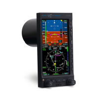
The basemap is comprised of symbols depicting the location of ight plan waypoints
and legs, airports, VORs, DMEs, NDBs, and intersections. The map is always oriented with
magnetic heading up and centered so that the current aircraft position coincides with
the aircraft ownship symbol. The current basemap feature display level and map range
is shown on the left side of the lower display (Figure 4-82).
1
Basemap Symbols
2
Aircraft Ownship Symbol
3
Basemap Feature Display Level
4
Basemap Range
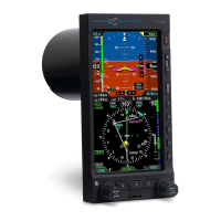
When enabled, the basemap underlies all other instruments and annunciations in the
lower half of the display. The GPS ight plan is rendered in either straight or curved
lines, as supported by the congured GPS navigator. The displayed symbol set includes
active waypoints, active ight plan leg, ight plan waypoints, ight plan legs, airports,
VORs, VORTACSs, TACANs, DMEs, intersections, and NDBs, and are layered accordingly
(Figure 4-83). There are ve feature display levels and eleven range levels that
determine which symbols and how their identiers are displayed.
Figure 4-82 Basemap (ARC Compass Mode Shown)
Figure 4-83
Basemap Symbol Set
NOTE
A VORTAC is shown as a combined
VOR and DME symbol. A TACAN is
rendered as a DME symbol.
1
2
3
4