
A
Angela BensonSep 8, 2025
What to do if C-MAP Ed.3 chart is not displayed on JRC JAN-701B Marine Radar?
- KKaren CollinsSep 8, 2025
If the C-MAP Ed.3 chart is not displayed, register the latest valid eToken license and import C-MAP Ed.3 chart.

What to do if C-MAP Ed.3 chart is not displayed on JRC JAN-701B Marine Radar?
If the C-MAP Ed.3 chart is not displayed, register the latest valid eToken license and import C-MAP Ed.3 chart.
What to do if JRC JAN-701B Marine Radar displays message “There is no licensed chart.” in Chart Portfolio?
If the message “There is no licensed chart.” is displayed in Chart Portfolio, insert the licensed CD into the CD-ROM drive.
What to do if the power was turned off during ARCS index creation on JRC JAN-701B Marine Radar?
If the power was turned off during ARCS index creation by Chart Portfolio, and Navigation & Planning cannot be started with an error message being displayed, start Chart Portfolio, select [Chart] - [ARCS] - [Regenerate Index] to create the chart index again.
What to do if JRC JAN-701B displays Error code (0XFFFFFFA) in Chart Portfolio?
If error code (0XFFFFFFA) is displayed in Chart Portfolio, input the proper authorization code you obtained again.
What to do if JRC Marine Radar displays Error code (0xFFFFFF73) while ARCS chart is imported in Chart Portfolio?
If error code (0xFFFFFF73) is displayed while ARCS chart is imported in Chart Portfolio, clean the CD-ROM, and perform the import procedure again.
What to do if ARCS chart will not be displayed on JRC Marine Radar?
If ARCS chart will not be displayed, contact the retailer from whom ARCS was purchased to check the details of the contract, because Chart Permit type was changed from trial version to regular contract.
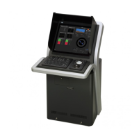
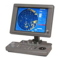
| Brand | JRC |
|---|---|
| Model | JAN-701B |
| Category | Marine Radar |
| Language | English |
Details on the dangers of high voltage and precautions to take when working with electrical apparatus.
Steps to take when encountering a victim of electric shock, including first aid measures.
Describes the functions of the ECDIS equipment, including ECDIS and Navigation Planning capabilities.
Lists the key features of the ECDIS system, covering chart display, navigation warnings, and user chart creation.
Illustrates an example system configuration showing how the ECDIS connects with other navigation sensors.
Details the functions of the operation panel buttons and how to control LCD brilliance.
Explains the different areas of the ECDIS screen: Chart Display Area, Display Panel, and Menu Title Bar.
Describes how to select menus, use the trackball, and navigate through menus and submenus.
Details the procedure for turning the ECDIS system ON and OFF, including necessary preparations.
Explains how to acknowledge and release alarms, including displaying the alarm list.
Explains how to display AIS/TT target information on the chart using operation panel or menu.
Describes how to select a route and the next waypoint for navigation.
Explains how to create routes using either the Table Editor or the Graphic Editor.
Details the various options for setting up routes, including default values and safety checks.
Introduces the two modes for chart editing: User Map Edit and Manual Update.
Overview of the automatic sailing system and how it interacts with the autopilot.
Details the settings for automatic sailing, including tracking gain, drift correction, and dead band.
Outlines the operational steps for ECDIS and autopilot during automatic sailing.
Details how to configure various alarm limits and area-related alarms.
Provides instructions for backing up and restoring system settings and data.
Describes how to access and exit the playback function to review logged data.
Details how to set the start date/time and play back the logged navigation data.
Provides a comprehensive list of system and navigation alarms, their meanings, and conditions.
Provides a guide to common problems and their solutions for the ECDIS unit.