Do you have a question about the SatLab SLT2 and is the answer not in the manual?
Measures directly on power-on; retains azimuth result.
Surveys long distances without prism, precise measurements on various materials.
Includes REM, offset, stakeout, resection, area calculation, road design functions.
Warnings on laser classification, direct/reflected beam exposure, and improper use.
Guidelines for safe laser use, user responsibility, and avoiding direct exposure.
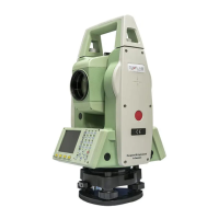
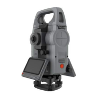
Labels and describes the main external parts of the total station.
Instructions for safely unpacking and storing the instrument.
Procedures for setting up, leveling, and centering the instrument.
Details on character entry methods for different input fields.
Instructions for deleting or clearing input characters.
Method for finding points by entering their exact number.
Using wildcards to search for points when the exact name is unknown.
Important notes and precautions for distance measurement procedures.
Selects the distance measurement mode (Single, Repeat, Tracking, etc.).
Setting the reflector type and prism constant for accurate measurements.
Setting atmospheric refraction coefficients and correction parameters.
Setting grid factor for coordinate calculations involving scale factor.
Setting the Horizontal Angle (HA) to 0 or a desired orientation.
Defining the instrument's station coordinates and height.
Recording point information using codes for post-processing.
Explanation of the level function and compensator operation.
Measuring points that are not intervisible or cannot have a prism.
Quickly switching between Prism (P) and Non-Prism (NP) modes.
Calculating station height using measured points.
Setting common units for measurements.
Accessing and configuring general instrument hardware settings.
Function to open or close the EDM Tracking mode.
Functions to control the laser pointer and screen backlight.
Managing jobs (create, select, delete) for measurement data.
Defining the instrument's station position for coordinate calculations.
Defining the instrument's orientation (direction) based on known points.
Overview and selection of measurement applications like Surveying, Stakeout, etc.
Recording measurement data for single points individually.
Viewing and managing measured data saved in the current job.
Defining stakeout points via job extraction or manual input.
Stakeout using polar coordinates (azimuth and distance).
Stakeout using longitudinal and perpendicular differences relative to a station.
Stakeout based on Cartesian coordinates and deviation values.
Tie distance calculation using a polygonal measurement method.
Tie distance calculation using a radial measurement method.
Calculating remote height when prism height is unknown.
Calculating plane coordinates using bearing and distance from a known point.
Calculating distance, direction, and height difference between two known points.
Calculating intersections of lines and circles using various methods.
Calculating offset points and extending baselines.
Defining the road path using methods like Element or Intersection.
Performing stakeout operations along a defined road path.
Defining a reference line and performing stakeout relative to it.
Defining a reference arc and performing stakeout relative to it.
Measuring points relative to a defined reference plane.
Managing jobs (create, select, delete) for measurement data.
Managing fixed points (search, add, edit, delete).
Managing measurement points (view, delete).
Managing codes (input, view, delete) for point data.
Displaying memory usage and formatting options.
Importing fixed points or code data to the instrument via RS232 or U Disk.
Exporting data (fixed points, measurements, codes) to computer or U disk.
Adjusting basic parameters like light, contrast, keys, units, port, baudrate.
Configuring EDM parameters (referenced to Chapter 3.2).
Accessing the adjustment menu for calibration.
Displaying current adjustment parameters like Vertical I.E.
Calibrating the index error of the total station.
Calibrating the vertical axis tilt compensation in X and Y directions.
Adjusting tilt zero and instrument constants for accuracy.
Resetting instrument parameters to factory default.
Displaying instrument type, SN, firmware, date, and time.
Setting the instrument's system date and time.
Process for upgrading the instrument's software via computer connection.
Procedures for checking and calibrating the tube level.
Checking the circular level after tube level calibration.
Checking and calibrating the telescope reticle for aiming accuracy.
Checking and calibrating the verticality of collimation and horizontal axes.
Compensating vertical index zero and setting collimation error.
Procedures for checking and calibrating the plummet.
Checking additive constant (K) and collimation axis parallelism.
Instructions, safety, and checkout for no-prism ranging functionality.
Details on telescope optics and angle measurement capabilities.
Specs for range, accuracy, and tilt compensation.
Specs for communication ports, display, and battery supply.
Examples and explanations of exported file formats (STAST001, XYZ, BKB, etc.).
| Tilt Sensor | Yes |
|---|---|
| IMU | Yes |
| Internal Memory | 8 GB |
| Resolution | 0.1mm |
| GNSS Technology | GPS, GLONASS, Galileo, BeiDou |
| RTK Positioning Accuracy | Horizontal: 8 mm + 1 ppm; Vertical: 15 mm + 1 ppm |
| Static Positioning Accuracy | Horizontal: 2.5 mm + 0.5 ppm; Vertical: 5 mm + 0.5 ppm |
| Communication | Bluetooth, Wi-Fi, 4G LTE |