System Operation
3-112
GNS-XLS Flight Management System
Rev. 3
Sep/96
b. Latitude - INSERT (N or S first, then degrees, minutes, and
hundredths).
c. ENTER Key - DEPRESS.
d. Longitude - INSERT (E or W first, then degrees, minutes,
and hundredths).
e. ENTER Key - DEPRESS.
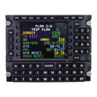
The DIF display shows the direction and distance in degrees,
minutes and hundredths of minutes from the FIX position to
the composite position.
f. ENTER Key - DEPRESS if position update is desired. NAVI-
GATION Page 1 is displayed
NOTE: If coordinate field flashes after entry, verify coordinates and
depress ENTER again.
If System Updated:
The VLF (RPU) sensor and the VPU interfaced to the updated CDU
are updated as well as the composite position, GPS, and IRS sen-
sors are not updated. Only IRS velocities are required to contribute to
the composite position.
If Update Not Desired:
3. NAV, PLAN, FPL, TUNE, VNAV, HDG, or d Key - DEPRESS
to cancel the position fix.
Using An Offset
This procedure is used to cross-check or update the system using an
offset from a known point such as VORTAC Radial and Distance.
Record Radial and Distance at the same time as performing Step 1.
NOTE: Overflying a predetermined radial and distance is not neces-
sary.
1. HOLD Key - DEPRESS.
2. Offset Waypoint IDENT - INSERT.
NOTE: If necessary, refer to the procedure for Creating An Offset
Waypoint.
 Loading...