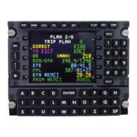
VHF Navaids
WAYPOINT:
Alphanumeric designator for
the Navaid. (Figure 2-77)
NOTE: If the waypoint has a
duplicate identifier in the
database, for another loca-
tion, the closest waypoint to
the aircraft position will be
shown and the country code
will be displayed beneath the
waypoint identifier. (Figure
2-78)
Press the NXT Key to
sequence to the next way-
point page with a different
country code. The PRV Key
can be used to sequence
backward through the way-
point pages. Additional
country codes and corre-
sponding POS coordinates
will be sequentially dis-
played.
POS:
The coordinates of the waypoint as stored in the database memory.
(Figure 2-77)
FREQ:
The VHF frequency for the station. (Figure 2-77)
VAR:
The magnetic variation of the station. (Figure 2-77)
ELEV:
The elevation in feet of the station (DME equipped VHF Navaids
only). A (-) indicates elevation is below sea level. (Figure 2-77)
NDB -ENTER:
The procedure for accepting the waypoint from the Navigation Data
Base is to depress the ENTER Key. (Figure 2-78)
Page Display Definitions
2-66
GNS-XLS Flight Management System
Rev. 3
Sep/96
WAYPOINT TRM
PORTU
POS N 3845.60
W02705.60
FREQ 116.20
VAR W 14
ELEV 172
NDB-ENTER
DATABASE WPT 2/4
Figure 2-78
WAYPOINT TRM
USA
POS N 3337.70
W11609.60
FREQ 116.20
VAR E 13
ELEV -110
NDB-ENTER
DATABASE WPT 1/4
Figure 2-77
 Loading...