CHAPTER 5 REFERENCE GUIDE
EFD1000/500 MFD Pilot’s Guide
Page 5-30 091-00006-001 REV B
EFD1000/500 MFD Pilot’s Guide
Page 5-31091-00006-001 REV B
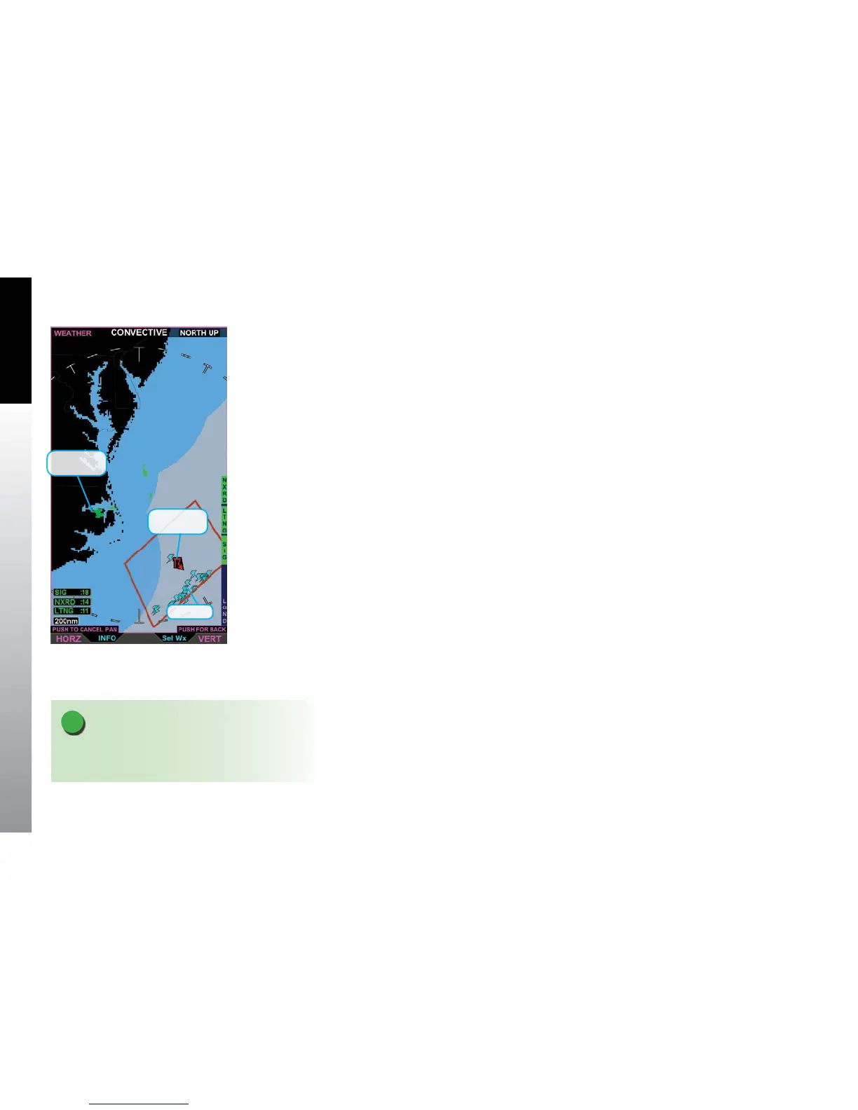
The Convective screen displays severe weather information overlaid on a basic weather
map. Precipitation is displayed as a color coded NEXRAD radar overlay on the basic
weather map. The LGND Hot Key displays a legend for the precipitation coloring.
Satellite lightning is displayed as cyan colored lightning symbols on top of the NEXRAD
radar information. Lighting symbols show the reported approximate location of cloud-
to-ground lightning strikes. The lightning symbols are displayed at full intensity fading
out over a 15 minute period. (Figure 5-33)
NEXRAD (Next-Generation Radar) is a network of 159 high-resolution Doppler radars
operated by the National Weather Service (NWS) to detect meteorological data for
the United States. The data can be processed and displayed in a mosaic map showing
patterns of precipitation and its movement. Each NEXRAD radar site has a maximum
range of 250 nm. Since NEXRAD data is not real-time, data is updated about every 10
minutes not including processing and dissemination time, it should be used for long-
range planning only. Do not use NEXRAD to penetrate severe weather. NEXRAD has
some limitations including:
• Although reectivity echoes are possible up to 248 nm, the interpretation of
the data doesn’t work beyond 186 nm, beyond which only the general shape of
storms can be made out.
• The inability to dierentiate between types of precipitation, e.g. hail versus
heavy rain.
• Since the radar beam is oriented ve degrees above the horizon, the farther from
the antenna, the higher the area scanned by the beam. This translates to limited
low storm detection farther from individual radar locations (i.e. tornados), and
conversely, limited high altitude storm detection directly above the radar location.
Figure 5-33
Convective Screen
NOTE
If coverage is not available, but radar is available, the
image is rendered as if all radar sites are valid.
Lightning
Convective
SIGMET
NEXRAD
Mosaic