CHAPTER 5 REFERENCE GUIDE
EFD1000/500 MFD Pilot’s Guide
Page PB 091-00006-001 REV B
EFD1000/500 MFD Pilot’s Guide
Page 5-1091-00006-001 REV B
Chapter 5
Reference Guide
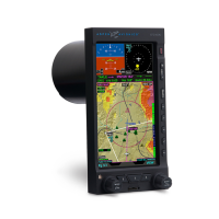
The EFD1000/500 MFD is a panel-mounted Electronic Flight Instrument
System (EFIS) that presents the pilot with a full-color moving Navigation
Map VIEW and a dedicated Terrain VIEW. Additionally there are three
optional VIEWS that provide Trac, Stormscope® WX-500, and Weather
information (all require additional receivers and possible subscriptions,
see the appropriate sections for detailed information).
The Navigation Map VIEW displays aviation data (e.g., Navaids, intersections, airports,
etc.) topographic information, boundaries, and GPS ight plan information. The Data
Link Weather VIEW provides graphical Convective, METAR, Echo Tops, Cloud Tops,
AIRMET/SIGMET, TFR, and Winds Aloft data. Each VIEW is clearly labeled in the upper left
corner of the window.
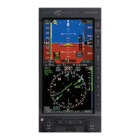
The MFD1000 MFD also has a Secondary Attitude Indicator and Secondary HSI VIEW
which provide the safety and condence of DuoSafe™ full PFD instrument redundancy.
If for some reason your EFD1000 PFD should fail, simply press the REV button on your
EFD1000 MFD and your full PFD display is right back in your primary instrument scan.
The Reference Guide oers detailed information about each of the available VIEWS
and step-by-step instructions to guide the pilot in the use and operation of each VIEW.
Sections 5.1. – 5.3.1. provide information for VIEWS that all EFD1000/500 MFDs have.
Sections 5.3.2. – 5.3.3. provide information for the three VIEWS that require additional
equipment and subscriptions to third-party vendors for data link information.
NOTE
If the GPS becomes invalid an Invalid GPS
annunciation displays. When the GPS position source is
unavailable, map functions such as panning, info etc.
will still be available. See Section 5.1.5.1. Invalid GPS
for detailed invalid GPS information.
NOTE
The MFD uses azimuthal projection for all maps and
geo-referenced data. .