Principles of Operation
1-866-4TOPCON www.topconpositioning.com
1-5
satellites available, the more valid and accurate the
position. Natural and man-made objects can block,
interrupt, and weaken signals, lowering the number
of available satellites.
• Integrity – Fault tolerance allows a position to have
greater integrity, increasing accuracy. Several factors
combine to provide fault tolerance, including:
–Receiver Autonomous Integrity Monitoring
(RAIM) detects faulty GPS and GLONASS satellites
and removes them from the position calculation.
–Wide Area Augmentation System (WAAS) creates
and transmits DGPS correction messages.
–Five or more visible satellites for only GPS or only
GLONASS; six or more satellites for mixed
scenarios.
–Current ephemerides and almanacs.
–Several algorithms to detect and correct faulty
information.
Conclusion
Surveyors can use Topcon GPS+ receivers to collect data
from a network of satellites and control stations to
triangulate precise points anywhere on Earth.
This overview simply outlines the basics of GPS and
GLONASS positioning. For more detailed information,
visit the TPS website (www.topconps.com/gpstutorial/).
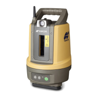
Receiver Overview
When power is turned on and the receiver self-test completes,
the receiver’s 40 channels initialize and begin tracking visible
GPS and GLONASS satellites. Each of the receiver’s
channels can be used to track C/A-L1, P-L1, or
P-L2 signals. The number of channels available allows the