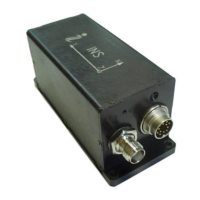
INS
GUI User’s Manual
Inertial Labs, Inc
TM
Address: 39959 Catoctin Ridge Street, Paeonian Springs, VA 20129 U.S.A.
Tel: +1 (703) 880-4222, Fax: +1 (703) 935-8377 Website: www.inertiallabs.com
70
GPS / GLO / Gal /Bei – shows what navigation systems are currently
used (GPS, GLONASS, Galileo, BeiDou).
e) In the “GNSS pos (m)” column the GNSS position relative to the start
point is shown. There change for GNSS latitude and longitude are
recalculated to change of linear coordinates in the North and East directions.
f) The “Baro data” column shows data measured by the pressure sensor:
“Temp.(decC)” – is temperature in C, “Press.(Pa)” – is pressure in Pascals,
“Alt.(m)” – is barometric altitude in meters.
There is detailed information about quality of GNSS solution above
section with position and velocity data in the window Fig. 5.1:
a) GNSS position type – shows what data were used by GNSS receiver for
in navigation solution for position calculation:
Single point position;
DGPS (pseudorange differential solution);
Solution calculated using corrections from SBAS;
PPP solution;
RTK (narrow-integer) solution;
RTK (other) solution;
Other.
b) PSR Iono Correction – shows what data were used for pseudorange
ionosphere correction:
Default (unknown or default Klobuchar model);
Klobuchar Broadcast;
SBAS Broadcast;
Multi-frequency Computed;
DGPS (pseudorange differential correction);
NovAtel Blended Iono Value.
Note if “INS Sensors Data” format is chosen then instead of “GNSS position type” and
“PSR Iono Correction” fields the GNSS extended solution status “Ext.sol.” is shown on
Fig. 5.1 in the “GNSS data” column. See Appendix C, Table C.15 for details).
To stop data output from the INS click the “Stop“ button .
 Loading...