8. Vector Chart Material
8-3
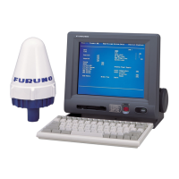
8.2.2 Chart legend of S57 chart
The chart legend, which provides various data about the chart currently displayed, can be toggled on and off by
placing the cursor in the sidebar, clicking the right mouse button, choosing Chart Legend from the menu then
pushing the scrollwheel.
This system is capable of showing more than one S57 chart at a time. This feature is called the multi-chart display.
If one S57 chart does not cover the whole display, the system will open more S57 chart cells for display, if
appropriate cells for the displayed area are available. The chart legend shows information about S57 charts
displayed on the electronic chart display area. The information is displayed with reference to your ship's position if
automatic TM reset is active, or with reference to the current position of the cursor if automatic TM Reset is OFF.
Cell name:
Name of chart.
Navigational purpose:
S57 charts are compiled for a variety of navigational purposes.
The navigational purpose, for which an individual S57 chart
has been compiled by a Hydrographic Office, is indicated in
this field. Alternatives are: Overview, General, Coastal,
Approach, Harbour and Berthing.
Issue date:
Issue date of the Base cell of the chart.
Edition number:
Edition number of the chart.
Last displayed update:
Number of last update, which is visible on the chart screen.
Update issue date:
Issue date of last update, which is visible on the chart screen
Last update appl. date:
Date to which the last update, which is visible on the chart screen, is effective.
Projection:
Projection of the chart. The projection is always Mercator.
Horizontal datum:
Horizontal datum of the chart data as published by the chart producer. By definition this must be WGS 84.
Vertical datum:
Vertical datum of the chart.
Sounding datum:
Datum used for soundings.
Quality of data:
Quantitative estimate of the accuracy of chart features, given by the chart producer.