Do you have a question about the STONEX R2 PLUS and is the answer not in the manual?
General notes for safe operation and instrument care.
Explains warning and caution symbols used in the manual.
Details safety standards for laser usage according to IEC.
Defines user requirements and necessary protective equipment.
Outlines manufacturer's limitations of liability for product misuse.
Information on battery power, symbols, replacement, and charging.
Step-by-step guide to setting up the instrument on a tripod.
Instructions for centering and leveling using circular level.
How to use the electronic level for accurate leveling.
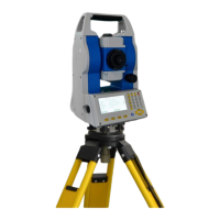
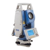
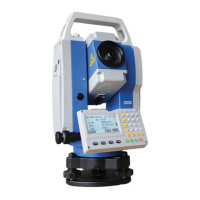
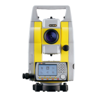
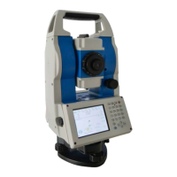
Identifies and labels the parts of the instrument.
Explains the function of various keys on the instrument keypad.
Describes the content and layout of the instrument's LCD display.
Illustrates the menu structure and navigation flow of the instrument.
Procedures for turning the instrument on and off.
Guide for inputting alphanumeric characters and numbers.
Instructions for configuring instrument settings like backlight and contrast.
How to set various measurement and instrument parameters.
Steps to measure the horizontal angle between two sighted points.
How to set a specific horizontal angle value on the instrument.
Guide to inputting occupied point coordinates and related data.
How to set the backsight azimuth for orientation.
Process for measuring 3D coordinates of a target.
How to stake out a point based on distance and direction.
How to stake out a point using its coordinates.
Performing stake out using Remote Elevation Measurement.
Calculating area using measured point data.
Calculating area using pre-existing coordinate data.
Finding a point using a single distance offset.
Finding a point using an angle offset.
Finding a point using two distance offsets.
Measuring distances between multiple points using MLM.
How to change the starting point for MLM measurements.
Determining station coordinates using known points.
Determining station elevation using known points.
Explains the steps involved in the resection calculation process.
Guidelines and precautions for performing resection accurately.
How to define a baseline for point projection.
Projecting points onto a defined baseline.
Defining a baseline for stake out line operations.
Staking out a point relative to a baseline.
Staking out a line relative to a baseline.
How to save coordinates during traverse surveying.
How to read saved coordinates for traverse.
Staking out an arc defined by two points and radius.
Staking out an arc defined by three points.
Inputting the starting station and coordinate for road design.
Inputting line, curve, and spiral elements for road horizontal design.
Inputting station, height, and length for vertical road elements.
Calculating staking points based on road design parameters.
Viewing the staking station data after calculation.
Executing the road stake out based on calculated points.
Managing road files, including selecting, renaming, and deleting.
Recording occupied station data, including coordinates and instrument details.
Collecting angle measurements and related data.
Recording distance and coordinate measurements.
Recording textual notes related to measurements.
Viewing previously recorded data entries.
Selecting the active job for data recording and management.
Selecting internal memory or SD card for data storage.
Choosing the active job for data operations.
Renaming existing jobs for better organization.
Deleting unwanted jobs and their associated data.
Transferring job data to a PC via serial port.
Copying jobs between internal memory and SD card.
Connecting the instrument to a PC using a USB port for data transfer.
Inputting known point coordinates manually via the keypad.
Inputting known point coordinates via RS-232C connection to a PC.
Deleting known point coordinates from memory.
Viewing stored known point coordinate data.
Clearing all known point data from the active job.
Editing the list of codes for data annotation.
Clearing all defined codes from memory.
Checking and adjusting the instrument constant for distance measurements.
Checking and adjusting the tubular level for precise leveling.
Checking and adjusting the circular level for leveling.
Checking and adjusting the optical sight.
Checking and adjusting the optical plummet.
Checking and adjusting the laser plummet.
Checking and adjusting the vertical cross-hair.
Checking and correcting horizontal collimation error.
Checking and cancelling tilt zero point error.
Checking and adjusting the vertical index error.
Checking EDM optical axis and telescope sighting axis error.
| Angle accuracy | 2" |
|---|---|
| Laser Plummet | Yes |
| Laser Class | Class 3R |
| Laser Wavelength | 635 nm |
| Battery Type | Li-ion |
| Operating Temperature | -20°C to +50°C |
| Weight | 5.2 kg |
| Distance measurement with prism | 5000 m |
| External memory | SD card |
| Operating System | Windows CE |
| Measurement Range | Up to 5000 m with prism |
| Accuracy | 2 mm + 2 ppm |