11. CHART ALERTS
11-3
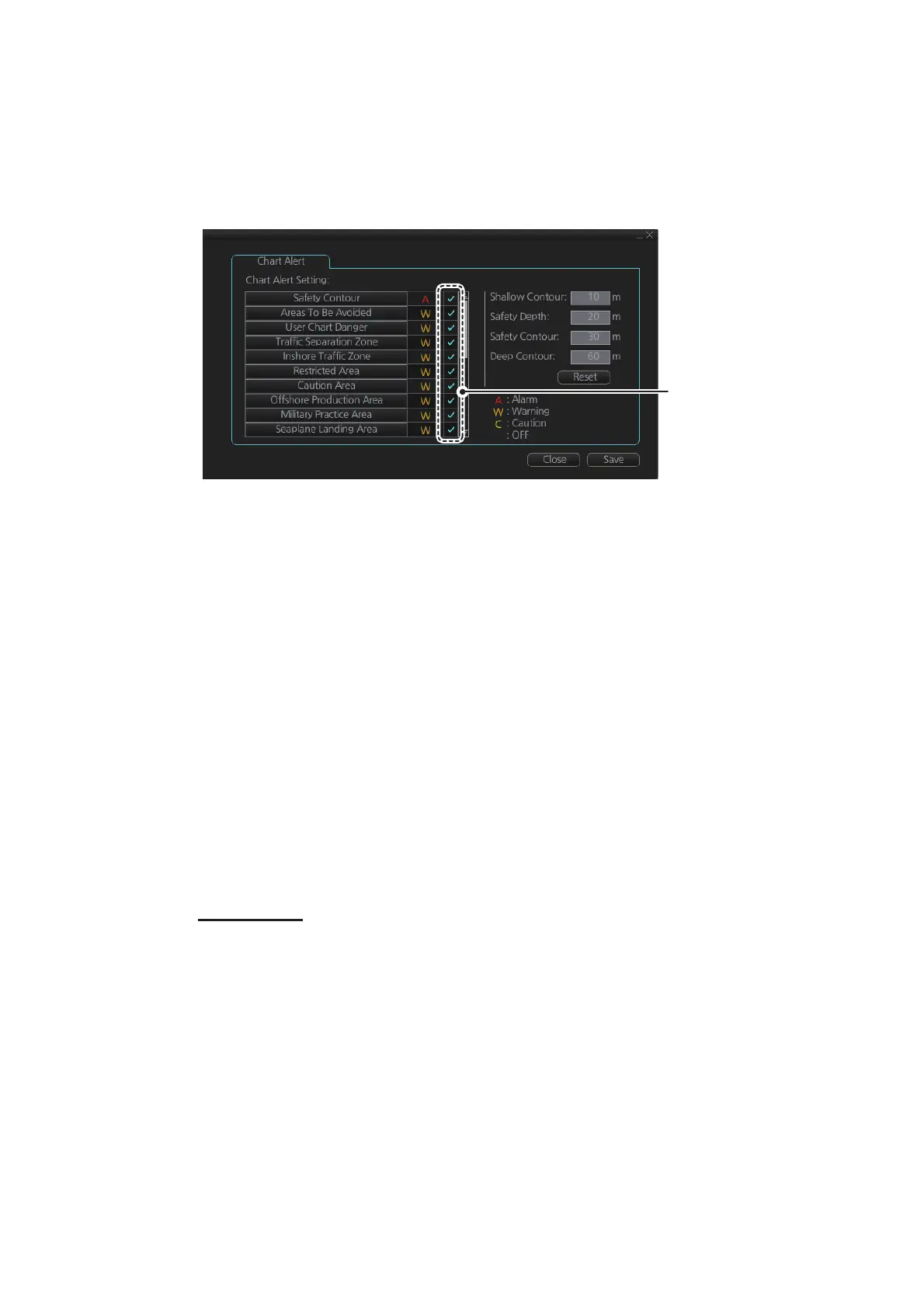
11.1.2 Chart object related settings
When using the Look-ahead function or monitoring a route, you can set up the method
in which to report chart alerts and also show/hide chart alerts.
1. Click the [DISP], [SET] and [Chart Alert] buttons on the InstantAccess bar™ to
show the [Chart Alert] page.
2. Click a letter indication to select the type of alert, warning or caution, to receive for
the given chart object. [Safety Contours] is fixed to “A” (Alarm).
W: Warning, visual and aural alerts
C: Caution, visual alert only
• W: Warning, visual and aural alerts
• C: Caution, visual alert only
• No display (OFF): No alert notification. Available with objects other than [No
Vector Chart].
3. Click the box to the right of the letter indication to show a check mark and show
the alert. Click the box again to remove the check in the box and hide the alert.
Checked alerts are highlight5ed according to priority:
• A (Alarm): Red color highlight
• W (Warning) and C (Caution): Yellow color highlight
4. Click the [Save] button to finish.
Note: C-MAP PROFFESIONAL+ charts may take several minutes to identify danger
areas.
List of areas
There are areas that the chart radar detects and provides the audible alert and/or vi-
sual alert if the estimated own ship position, or planned or monitored route, crosses
the area defined on the [Chart Alert] page. You can select from the following areas:
• Safety Contour
• Navigational Hazard
• Areas To Be Avoided
• User Chart Danger
• Traffic Separation Zone
• Inshore Traffic Zone
• Restricted Area
• PSSA Area
• Caution Area
• Offshore Production Area
• Military Practice Area
• Seaplane Landing Area
• Submarine Transit Lane
• Anchorage Area
• Marine Farm/Aqua Culture
• No Vector Chart
• Too Many Dangers
• UKC Limit
• Sounding UKC Limit
• Non-official ENC
• Not Up-to-date
• Permit Expired
Check to show alerts ,
uncheck to hide alerts