ENTERTAINMENT
09–20–29
09–20
End Of Sie
NAVIGATION FUNCTION
CHU092066000S06
Outline
• A vehicle's position is measured by a hybrid method of autonomous navigation (using yaw-rate signals from the
gyro sensor and vehicle speed signals from the DSC HU/CM (with DSC) or ABS HU/CM (with ABS) and GPS
navigation (using signals from GPS satellites). Accurate detection of the vehicle's position is possible based on
the adoption of a map-matching function which specifies the vehicle's position as compared with the map data
read from the DVD-ROM and the vehicle’s position measured from autonomous navigation and GPS
navigation.
• Guidance to destination is provided via display of the recommended route on the map screen, as well as voice
messaging guidance at intersections and points of divergence.
• Based on inputted signals and information on the DVD-ROM, the following features are available:
— Destination can be selected based on address, intersection, POI (Point of Interest), history, memory or
map.
— Route information is available in map and guide mode.
— Voice guidance and menus are available in six languages.
— A map screen that displays maps in twelve steps with scales from 100 m to 500 km {1/20 to 250 mile}.
— A map screen that displays routes according to Shortest Route and Avoid Motorway functions.
— A detour function which provides three routes to select from based on streets selected to avoid, up to five
via points and calculation of set detour distance.
— A wide variety of preferential settings are available.
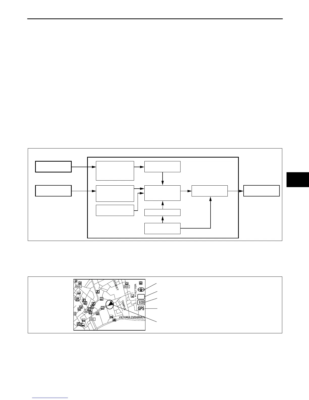
Block Diagram
Map Screen Selection
Current position map
• The location of the vehicle and surrounding area are shown.
• By pressing the [POS] button, the display switches to guide mode. (Only while in route guidance.)
CAR-NAVIGATION UNIT
GPS ANTENNA
SIGNAL FROM
SATELLITE
ABS HU/CM (WITH ABS) OR
DSC HU/CM (WITH DSC)
VEHICLE
SPEED SIGNAL
DETECTION OF
CURRENT
MEASURED
POSITION
CORRECTION
BY GPS
DETECTION OF
VEHICLE TRAVEL
DISTANCE
DETECTION OF
VEHICLE'S
POSITION
MAP MATCHING
YAW-RATE SIGNAL
GYRO SENSOR
MAP DATA
DVD-ROM
LCD UNIT
DISPLAY
CHU0920S116
1/20mi
MAP ORIENTATION
MAP SCALE
CLOCK
GPS RECEPTION INDICATOR
(LIGHTS UP WHEN RECEIVING SIGNALS
FROM 3 OR MORE SATELLITES.)
VEHICLE POSITION
CHU0920S117
 Loading...