Garmin G2000 Pilot’s Guide for the Cessna T240
190-01263-01 Rev. A
380
Hazard avoidance
SYSTeM
overvieW
FLiGHT
inSTrUMenTS
eiS
aUdio & cnS
FLiGHT
ManaGeMenT
Hazard
avoidance
aFcS
addiTionaL
FeaTUreS
aPPendiceSindeX
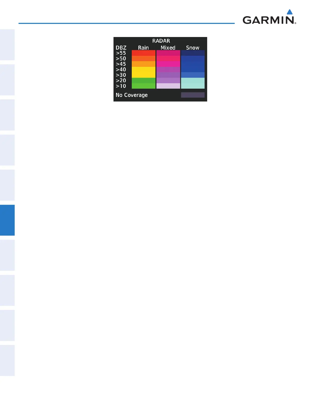
Figure 6-56 Garmin Connext Radar Legend
The display of no radar coverage is enabled when Precipitation is selected for display. Areas where
precipitation radar coverage is not currently available or is not being collected are indicated in gray shade of
purple. A white boundary line with white tick marks depicts the selected coverage area of the weather data
request (as defined as the Data Request window). This boundary encloses the precipitation data when this
weather product is displayed.
reflectivity
Reflectivity is the amount of transmitted power returned to the radar receiver. Colors on the Precipitation
display directly correlate to the level of detected reflectivity. Reflectivity as it relates to hazardous weather
can be very complex.
The role of radar is essentially to detect moisture in the atmosphere. Simply put, certain types of weather
reflect radar better than others. The intensity of a radar reflection is not necessarily an indication of the
weather hazard level. For instance, wet hail returns a strong radar reflection, while dry hail does not. Both
wet and dry hail can be extremely hazardous.
The different radar echo intensities are measured in decibels (dB) relative to reflectivity (Z). Weather
radars measure the reflectivity ratio, or the energy reflected
back to
the radar receiver (
designated by the
letter Z)
. The value of Z increases as the returned signal strength increases.
raDar limitationS
Radar images may have certain limitations:
• Radar base reflectivity does not provide sufficient information to determine cloud layers or precipitation
characteristics (wet hail vs. rain). For example, it is not possible to distinguish between wet snow, wet
hail, and rain.
• Radar base reflectivity is sampled at the minimum antenna elevation angle. An individual radar site
cannot depict high altitude storms at close ranges. It has no information about storms directly over the
site.
• When zoomed in to a range of 30 nm, each square block on the display represents an area of four square
kilometers.
This manual downloaded from http://www.manualowl.com