OPERATOR’S MANUAL
CMA-9000 FLIGHT MANAGEMENT SYSTEM
SECTION 1
INTRODUCTION
SYSTEM OVERVIEW
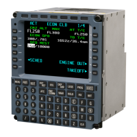
The CMA-9000 Flight Management System (FMS) provides a complete Global Navigation System (GNS) and
area navigation (RNAV) solution for world-wide four-dimensional aircraft navigation in the oceanic/remote, en-
route, terminal and non-precision approach. It includes extensive flight management capabilities and a full
range of navigation and flight planning features, together with simple route and flight plan creation and
modification procedures. A world-wide subscription navigation database, stored in a non-volatile memory,
provides the FMS with information on waypoints, navaids, airports, terminal area procedures, airways... In
addition the database is capable of storing customer defined routes and waypoints. The CMA-9000 also
integrates the functionality of Radio Management System (RMS) and Multi-Function Control Display Unit
(MCDU) into a standalone, cockpit mounted enclosure.
In dual/triple FMS installations, the synchronization is established automatically on power-up.
Flight management capabilities include:
• Multi-sensor navigation modes
• Standard Instrument Departure (SID)
• Standard Terminal Arrival Routes (STAR)
• GPS instrument approaches
• Direct-to/intercept navigation, holding patterns, procedure turns, arcs and offset tracks
• Automatic waypoint sequencing, with and without turn anticipation
• Required and actual navigation performance (RNP/ANP)
• Required time of arrival (RTA)
• Fuel management and radio tuning functions
• Vertical flight planning and management of an overall vertical profile (VNAV)
The FMS accepts data from the following external navigation sensors, if installed:
•
Distance Measuring Equipment (DME)
•
VHF Omni-directional Range (VOR)
•
External GPS
•
Inertial Reference System (IRS)
•
Air Data Computer
Information from these sensors is combined to determine aircraft position. This position is then used for
navigating along a programmed flight plan created by selecting procedures/waypoints from the navigation
database.
Page 1-1
August 17, 2010