1.P
ointtopointruler.
2.Vesseltopointruler.
Multiplerulerscanbecreatedanddisplayedsimultaneously.
Measuringvesseltopoint
Tomeasurethedistanceandbearingofalocationfromyourvessel’slocation
followthestepsbelow.
1.Select(pressandhold)ontherequiredlocation.
Thecontextmenuisdisplayed.
2.Select[moreoptions].
3.Select[Measure].
4.Select[Measure-fromboat]fromthepop-overoptions.
Arulerlineisdrawnonthescreenfromyourvessel’slocationtothe
cursor’slocation.Thedistanceandbearingfromyourvesselisalso
displayedinaninformationbox.
5.Ifyouwouldliketokeeptherulerlineselect[Keepruler]fromthetopof
thescreen.
Therulerwillbepermanentlydisplayedonscreen,thevesselendofthe
rulerwillmovewithyourvesselupdatingdistanceandbearingasyou
travel.
6.Ifyoudonotwanttokeeptherulerselect[Exit]fromthetopofthescreen
andselect[Discard]fromtheconfirmationdialog.
Measuringpointtopoint
Tomeasurethedistancebetween2pointsandbearingtothefirstpoint
followthestepsbelow.
1.Select(pressandhold)anylocationonthescreen.
Thecontextmenuisdisplayed.
2.Select[moreoptions].
3.Select[Measure].
4.Select[Measurebetweenpoints]fromthepop-overoptions.
5.Selectthelocationforthefirstpoint.
6.Selectthelocationforthesecondpoint.
7.Ifyouwouldliketokeeptherulerlineselect[Keepruler]fromthetopof
thescreen.
Therulerwillbepermanentlydisplayedonscreen.
8.Ifyoudonotwanttokeeptherulerselect[Exit]fromthetopofthescreen
andselect[Discard]fromtheconfirmationdialog.
Deletingrulers
Y oucandeleteindividualrulersorallrulersatthesametime.
1.Select(pressandhold)onarulerpoint.
2.Select[Deleteruler]fromthecontextmenu.
Alternativelyyoucandeleteallrulersbyselecting[Removeallrulers]from
thecontextmenu.
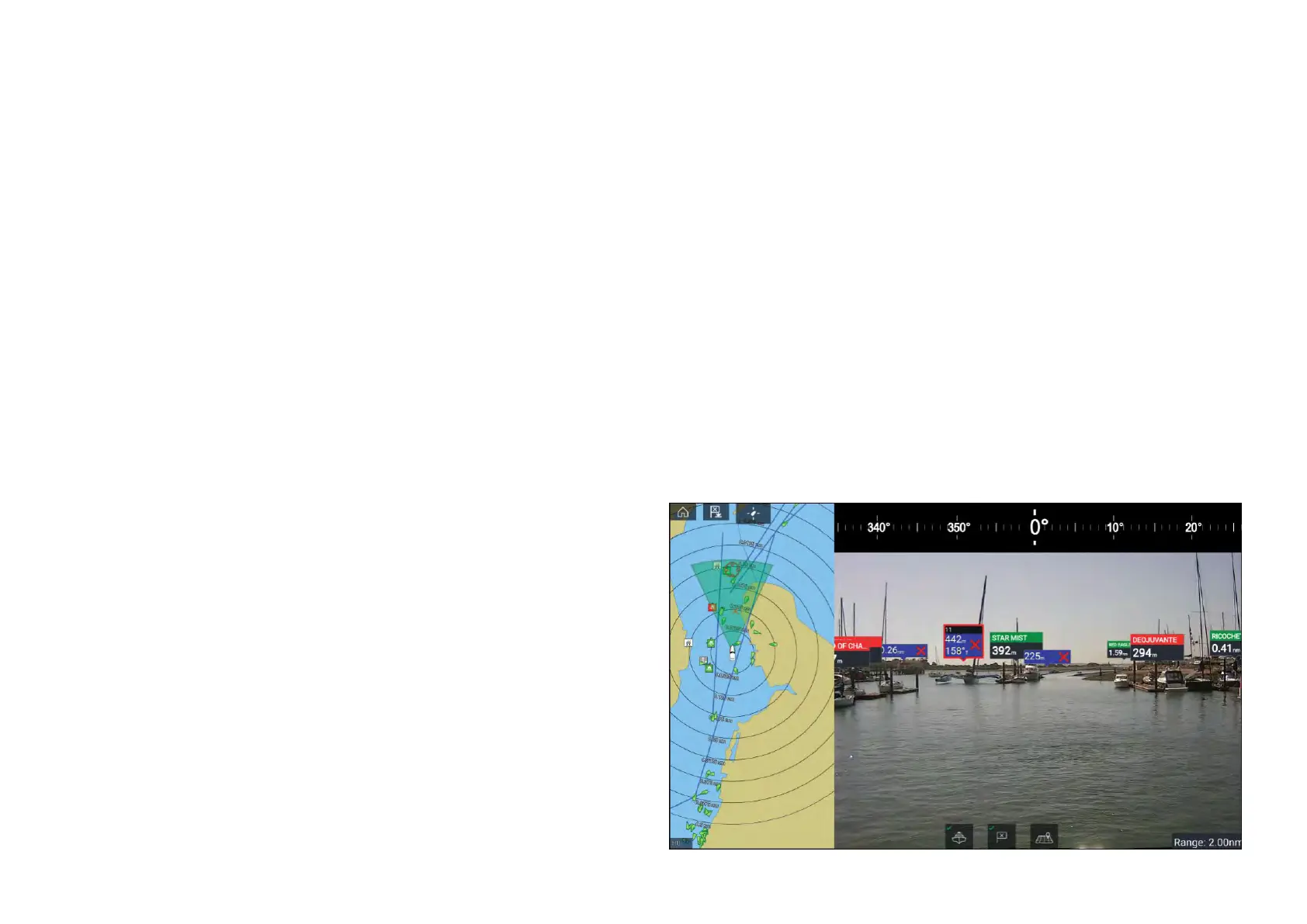
11.15ClearCruise™AugmentedReality
TheChartapphasadditionalAugmentedRealityfeatures,whichareavailable
whenanAR200andacompatibleIPcameraareconnected.
AugmentedRealityfeaturesmustalsobeenabledandconfiguredinthe
Videoapp.
WiththeAugmentedRealityfeaturesenabled,theAISTarget,Waypointand
ChartObjectdataavailableintheChartappwillalsobeavailableinthevideo
app,wherethedatawillbeoverlaidontothelivevideofeed.
198

 Loading...


