14. 1Anchormode
Anchormodeshouldbeusedwhenyourvesselisatanchor.Anchormode
usesyourvessel’sGNSS(GPS)positiontorecordyourlocationwhenyour
anchorhitsthebottom.Anchormodewillcalculateifyourvesselhas
draggeditsanchorfromitsoriginallocation,basedonspecifiedvaluesand
thentriggertheAnchordragalarm.T oactivatetheanchordragalarmthe
Anchoringwizardmustbecompleted.
Note:
[Anchormode]doesnottak
eintoaccounteffectsthattidemayhaveon
chainlengthordepthvalues.
BeforeAnchormodecanbeusedthesystemrequiresthefollowingdetails:
•GNSS(GPS)position—viaaconnectedreceiver .
•Depth—viaaconnectedtransducer.
•Lengthofyourvessel(bowtostern)—valuespecifiedin[Boatlength]field.
•GNSS(GPS)receiverdistancefromvessel’sbow—valuespecifiedin[Bow
toGPS]field.
[Boatlength]and[BowtoGPS]canbesetinthe[Boatdetails]settingstab:
[Homescreen>Settings>Boatdetails].Ifthevalueshavenotbeensetthen
youwillbepromptedtoenterthemwhenactivating[Anchormode]forthe
firsttime.
Note:
Ifdepthdataandpositiondataarenotavailableyouwillnotbeableto
starttheanchoringwizard.
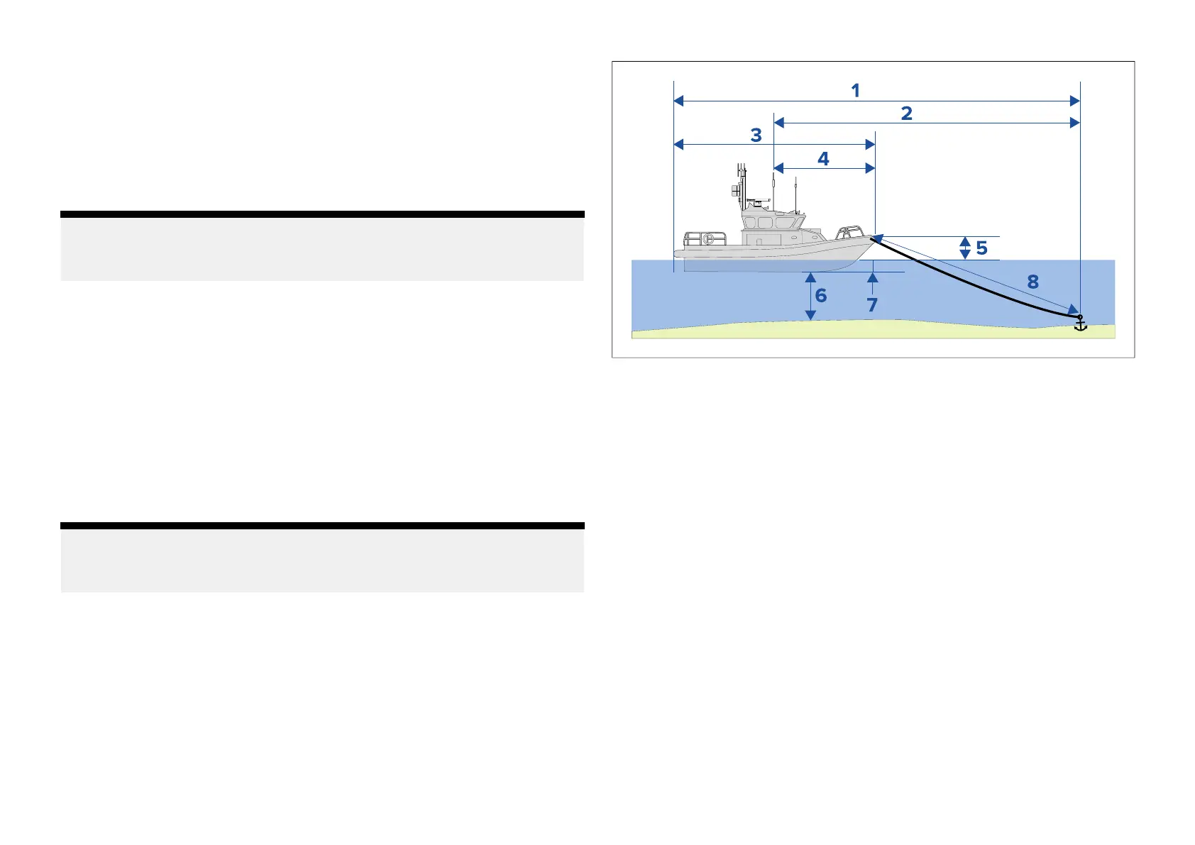
Anchormodeusesthefollowingdata,measurementsandcalculations:
1.Maximumswingradius—calculationdeterminedusingBoatlength,
BowtoGPSdistance,ChainlengthandDepth.
2.Draglimit—calculationdeterminedusingMaximumswingradius,Boat
lengthandBowtoGPSdistance.
3.Boatlength—userdefinedmeasurement.
4.BowtoGPS—userdefinedmeasurement.
5.Waterlinetodeck—1meterisaddtothecalculationtoallowforthe
distancefromthewaterlinetothedeck.
6.Depth—datareceivedfromdepthtransducer.
7.Depthoffset—thespecifieddepthoffsetisaddedtothecalculation.
Thedepthoffsetisbasedonyourtransducersettings(Zeroif[Below
transducer]isselected,positivevalueif[Belowwaterline]isselectedand
negativevalueif[Belowkeel]isselected.)Referto:p.262—Depthoffset
8.Chainlength—defaultcalculationbasedon4timesdepth.Chainlength
canbealteredmanuallytospecifyactualchainlength.
TheanchordragalarmistriggeredifyourGNSS(GPS)receiverpassesthe
distancefromtheoriginalanchorpositionbythespecifieddraglimitdistance.
Whenanchormodeisactiveatrackofyourvesselsmovementswillbe
recordedandrepresentativegraphicswillbedisplayedonscreeninthechart
app.
216

 Loading...


